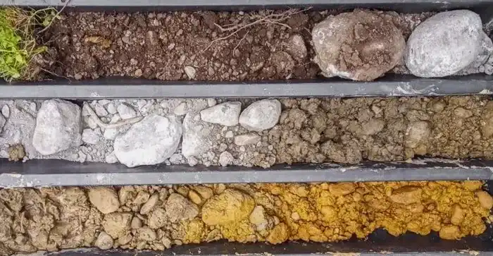
Around Birmingham, we keep running into the same situation on commercial lots—the geophysical survey says one thing, but the backhoe tells a different story the minute you open up the ground. That gap between modeled data and what’s actually sitting beneath the topsoil is where exploratory test pits earn their keep. The Piedmont residual soils here, weathered straight from the underlying schist and quartzite of the Talladega belt, don’t always read cleanly on remote sensing alone. When a CPT test hits refusal on a floating boulder at eight feet, you need eyes on the profile to sort out whether you’re dealing with an isolated cobble or the top of a weathered rock horizon that could change your entire foundation design. Our crew logs every pit using the Unified Soil Classification System per ASTM D2488, and we tie the observations back to the IBC site class assumptions that drive the structural calcs. In the Red Mountain corridor especially, where cut-fill transitions are common, a well-placed test pit can save you from expensive over-excavation or, worse, a footing bearing on undocumented fill.
In Piedmont residual soils, the difference between weathered rock and intact bedrock can be six feet vertical across a single building pad—test pits give you the ground truth that remote sensing misses.
Our approach and scope
One mistake we see contractors make in the Birmingham metro is assuming that a single borehole log from one corner of the site characterizes the whole parcel. The saprolite here—that transition zone between fully weathered rock and intact bedrock—can vary six feet in elevation across a hundred-foot span, and you won’t catch that variation with a drill rig alone. Exploratory test pits let you walk the profile, measure the depth to refusal with a tape, and photograph the contact between residual clay and partially weathered schist in a way that even the best split-spoon sample can’t replicate. We log groundwater seepage at the saprolite interface, note the presence of manganese oxide staining that signals long-term perched water, and collect bulk samples for
grain size analysis and Atterberg limits back at the lab. For sites where fill history is undocumented—think old industrial parcels near the railroad corridor in North Birmingham—pits are the fastest way to identify buried debris, ash layers, or brick fragments that would otherwise show up as surprises during mass grading. The data feeds directly into bearing capacity checks and lateral earth pressure assumptions for
retaining walls, especially where you’re cutting into weathered rock and need a realistic friction angle for the design.
Local ground factors
A five-story mixed-use structure off Lakeshore Parkway taught us this lesson the hard way a few seasons back. The geotech report relied on borings spaced at 150-foot centers and missed a pocket of undocumented fill—old construction debris mixed with fat clay—that spanned half the proposed elevator shaft footprint. The excavator opened a test pit at the shaft location on a Thursday afternoon, and by Friday morning we had logged six feet of uncontrolled fill overlying residual silty sand with a perched water table at the contact. Had that gone unnoticed, the shaft would have been founded on material with zero compaction control and differential settlement potential that could have cracked the elevator rails within the first two years. Birmingham’s karst features, while less dramatic than what you’d see in Huntsville, still produce localized collapse zones in the carbonate units north of town, and a liquefaction screening program isn’t complete without direct observation of saturated, loose granular layers. The cost of a test pit is measured in hundreds of dollars—the cost of redesigning a foundation after grading is done runs into the tens of thousands, and that’s before you factor in the construction delay.
Common questions
What is the typical turnaround time for scheduling exploratory test pits in Birmingham?
For most sites within the Birmingham metro, we can mobilize within five to seven business days after utility locates are cleared. The field work itself—excavation, logging, sampling, and backfill—is typically completed in one day for up to four pits on a standard commercial lot. The written field log package follows within three business days.
How deep can you go with a test pit in the Piedmont residual soils around Birmingham?
With a standard rubber-tire backhoe, we generally reach 12 to 14 feet in competent residual soil before the machine runs out of reach or encounters refusal on partially weathered rock. In areas like the Red Mountain corridor where the saprolite transitions to intact quartzite at shallower depths, refusal often occurs between 6 and 10 feet. We coordinate with the operator to bench or step the sides beyond 4 feet per OSHA requirements.
Do you backfill and compact the test pits after inspection?
Yes, backfill and compaction are standard with every pit. We replace excavated material in controlled lifts, compact each lift with a mechanical tamper, and finish with a mounded cap to account for settlement. On sites where the pit penetrates through pavement subgrade or future building pads, we can install a bentonite plug at the surface to prevent surface water infiltration into the backfill column.
What does an exploratory test pit program typically cost in the Birmingham area?
Can test pits replace soil borings for foundation design in Jefferson County?
Test pits complement borings but rarely replace them entirely for structural foundation design. Pits provide excellent visual detail in the upper 10 to 14 feet—ideal for shallow footing evaluation, fill characterization, and utility trench assessment—but they cannot achieve the depth needed for deep foundation design or liquefaction analysis. Most projects in Birmingham benefit from a combination of borings with SPT sampling for deeper strata and test pits for near-surface verification.